


Chicxulub Crater
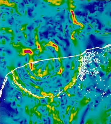
Large (150-180 km wide and 20 km deep), partially submerged, multi-ringed impact craterBowl-like depression ("crater" means "cup" in Latin) on the surface of a planet, moon, or asteroid. Craters range in size from a few centimeters to over 1,000 km across, and are mostly caused by impact or by volcanic activity, though some are due to cryovolcanism. Click on Term to Read More straddling the northwest coastline of the Yucatan Peninsula in Mexico. It is named after a village located near its center (21° 20′ N, 89° 30′ W).
The Chixculub Crater is believed to have formed 66 million years ago by impact of an asteroid measuring some 11 to 81 km across. Evidence for impact includes shocked quartzComposed of SiO2, quartz is one of the silica group minerals most common in Earth's crust, but never found in meteorites as inclusions visible to the naked eye. Quartz in meteorites has been found in very small quantities in eucrites, other calcium-rich achondrites, and in the highly reduced E chondrites1. Click on Term to Read More grains, elevated Ir and other platinum-group-element (PGEElements with geochemical properties similar to Pt (platinum) including Ru, Rh, Pd, Os, Ir, and sometimes Au. These occur in nature in close association with one another and with Ni and Cu. They are among the least abundant of the Earth’s naturally occurring elements. Click on Term to Read More) abundances, impact melt and sueviteTerrestrial breccia composed of angular fragments of different rock types and glass inclusions. Glass can make up more than half of the volume of suevite. Mineral grains in the rock fragments commonly display shock-metamorphic effects. Suevite was named after a rock found at the Ries Crater in southern Germany (photograph).. Environmental effects resulting from the impact are thought to have been responsible for the mass extinctionIn astronomy, the dimming of starlight as it passes through the interstellar medium. Dust scatters some of the light, causing the total intensity of the light to diminish. It is important to take this effect into account when measuring the apparent brightness of stars. The dark bands running across portions Click on Term to Read More as recorded at the Cretaceous-Tertiary (K-T) boundary, now called the Cretaceous-Paleogene (K-P) boundary because of a recent revision in stratigraphic terminology.
The name “Chicxulub” is derived from the Maya language and pronounced Chik-Shoo-Loob with the “oo” being pronounced as in the word “wood”.
Some or all content above used with permission from J. H. Wittke.
